Hiking Nevados de Sollipulli in Chile | The Ultimate Guide

Nevados de Sollipulli, or just Sollipulli, is an absolutely stunning (and massive) ice-filled volcanic caldera and volcano complex. Located just north of the adventurous town of Pucón in central Chile, Sollipulli — while definitely not the most famous volcano in the area (that likely goes to Villarrica) — is still 100% worth seeking out, especially if you are interested in seeing a slightly different type of volcanic landscape.
The trail to the caldera rim is less than 8 miles round trip (or 12.8 kilometers), with just around 3,000 feet of elevation gain (but somehow it doesn’t feel that steep while hiking…). Plus, while the Sollipulli caldera is definitely the star of the show, along the trail, you will also be able to check out a large araucaria forest, take in some amazing views of nearby Llaima volcano and maybe see a bright blue glacier lake.
If this epic Chile hiking trail sounds like fun to you, then keep reading for our full Sollipulli hiking guide.
➳ Check out the Alltrails hiking map here.

\\ How to Get to the Sollipulli Trailhead
Located in the heart of the Araucania region in central Chile, the Sollipulli trailhead is relatively easy to reach from multiple towns — including the highly popular outdoor adventure town of Pucón, as well as the capital of the region, Temuco.
While public buses do run between some of the towns nearby, from what we gathered, it would not be possible to take a bus all the way up to the trailhead. It is highly likely that the closest you could get to the start of the hike if taking public transportation would be at the turn-off from the main highway and onto the dirt road. From that point, you would still need to hike up (and we mean up) another 12.3 kilometers / 7.6 miles before ending at the national reserve and the start of the trail.
Therefore you would instead need your own form of transportation. Luckily, it is pretty easy to rent one in either Pucón, Villarrica or Temuco.
➳ Learn more about renting a car in Chile here.


DRIVING DIRECTIONS TO THE NEVADOS DE SOLLIPULLI TRAILHEAD
FROM PUCÓN
If starting in Pucón, you will need to head out of town on the International Highway towards the town of Villarrica. Once you pass through Villarrica, turn right immediately after crossing the bridge outside of town. Take this road (S-69) until it meets up with S-61 (approximately 38 kilometers / 23.6 miles later) in the town of Los Laureles. Do know that once you pass through the very small town of Pedregosa the road turns to dirt (it is quite washboard-y).
Once you get to Los Laureles, turn right onto S-61 and keep driving for about another 1.5 hours. Along the way, you will pass through the towns of Cunco and Melipueco, the former of which has a couple of restaurants and gas stations.
Once past Melipueco, keep an eye out for a large sign for Reserva Nacional Villarrica. Soon enough you will see a turn on the right onto S-571, another dirt road. Take this road until it T’s off with S-575. Turn left here and keep driving all the way up until the road eventually ends at the reserve entrance station.
💬INSIDER TIP: we highly suggest having an offline driving map with you just in case you get turned around on the backroads up to the trailhead. We used maps.me and had no problems making our way to the entrance station of the reserve.
TOTAL DISTANCE: 147 kilometers / 91.3 miles
TOTAL DRIVING TIME: 2.5 hours
FROM TEMUCO
Make your way out of the large city of Temuco on S-51, which heads towards the town of Miraflores. Drive S-51 until it meets up with S-61. Once here, turn left and drive into the town of Cunco. Just like the directions above, once out of Cunco keep driving on S-61 until you reach the turn-off for Reserva Nacional Villarrica and road S-571. Once on S-571 (and eventually S-575) drive for another 12.3 kilometers until you reach the trailhead.
TOTAL DISTANCE: 120 kilometers / 74.5 miles
TOTAL DRIVING TIME: 2 hours and 15 minutes


\\ The Best Time to Hike Sollipulli
You can hike the Sollipulli trail year-round — though sometimes the reserve does close it if there are dangerous conditions present (check the status of the trail here).
Between the months of December and February (summer) you can expect the trail to be relatively clear of snow and very easy to follow. We hiked in early January and only found a bit of snow right at the end — and even that was so packed down that we were able to hike across it with very few problems.
During the winter season (June — August) you will need to wear proper clothing and snowshoes in order to reach the caldera. Do know that there are a few steep sections along the trail that may or may not be prone to avalanches and slides, not to mention a fair bit of slick ice. If you are planning to hike the trail during the winter, make sure to come with the proper safety gear and an offline map (the trail may not be as easy to follow).
\\ What to Bring With You to Hike Nevados de Sollipulli
HIKING BOOTS
You will want some solid hiking boots for Sollipulli. While the trail is not very challenging, half of it is on old volcanic lava fields (aka loose dirt and sand). The trail can be quite slick in places — especially on the last bit of the trail near the caldera rim. Plus, there are a few snowy sections that can be slick when walking downhill on them. These hardy boots by Asolo should work perfectly. Check them out here.
TREKKING POLES
Similarly, you may want some trekking poles — especially if you are someone who struggles with slick downhills or has bad knees. There were definitely a few parts where having that extra bit of support would have been helpful, especially on the hike down. These poles by Black Diamond would be a great addition to your hiking gear. Check them out here.

WARM JACKET
While hiking in the summer should afford you some awesome sunny days, it is likely that no matter the weather the icy wind at the top of the caldera rim will make you wish you had a warm jacket (or thankful you brought one). This one by Patagonia is warm enough to work on the caldera rim (and many other hikes in Chile) while still being small enough to pack down easily when you don’t need it. Check it out here.
GLOVES & HAT
The final pieces of hiking gear you may want to bring with you on the Sollipulli hike will be a warm pair of gloves and a hat. This pair of gloves from Hestra are small enough to not take up too much space in your hiking bag, yet still warm enough to keep your hands cozy while up on the caldera rim. Likewise, this cozy and simple stocking cap from Patagonia should do the trick no matter how much wind there is at the top. Check out the gloves here and the hat here.


HIKING NEVADOS DE SOLLIPULLI | THE ADVENTURE BREAKDOWN
TOTAL DISTANCE: 12.5 kilometers / 7.8 miles
ELEVATION PROFILE: 1,060 meters / 3,480 feet gained
TIME NEEDED: 5–6 hours, not including the driving time to the trailhead
TRAIL CONDITIONS: easy to follow the trail, with half in an araucaria forest and half out on the volcanic field (where there is no shade), the last bit can be a bit tough as it is on scree and sand.
START | The trail starts right from the parking lot at the end of the road. There is a small guard station where you may see one of the CONAF rangers. It is free to enter the reserve but you will have to add your name to the check-in book (this is so they know if someone doesn’t make it out and they have to send a search party). There are also bathrooms and water available at the trailhead.
1 | Once you leave the trailhead, you will walk through a thick forest of coigües, lengas and ancient araucaria trees (also knowns as Monkey Puzzle trees). During this section of the trail, you should have plenty of shade and easily be able to follow the trail (there are numerous signposts along the way).


2 | You will hike through the thick forest for the first 1.5 miles (2.4 kilometers) before the trees eventually give way to a wide-open volcanic plain. Once you leave the trees behind, you will be completely out in the sun for the rest of the hike (so consider applying more sunscreen or donning your sun-protective clothing here).
3 | Keep following the singletrack trail along the edge of the volcanic plain as it climbs steadily up to a ridgeline where there are some epic views of the nearby Llaima Volcano. There are also some really cool araucaria trees in this section.

4 | Once at the top of that ridgeline, you will need to turn left and follow the trail down a small ravine and then back up the other side (don’t worry it isn’t that steep). This part of the trail is a bit sandy and slick though, so definitely take your time and don’t rush the downhill parts.
5 | Soon you will reach the other side of the volcanic plain. From there you can clearly see the trail as it meanders up the ridgeline and onto the top of Sollipulli. As with the first part of the open section of the trail, this part is mostly loose sand and dirt so it can be quite slick. Take your time walking up and make sure to look behind you at the amazing view of the nearby mountain landscape — including of Llaima and Sierra Nevada.
6 | There is a nice mirador about 3 miles (4.85 kilometers) up the trail. Consider stopping here for a quick snack break. This part of the trail is really pretty and it gives you the chance to look out at the mountains to the north as well as out toward the different volcanic colors along the mountains around you. From the mirador, it is only another mile to the very top.


7 | The trail flattens out a bit after the mirador. Follow it as it heads into a likely snow-filled gully. The trail will soon cross a large snowfield, though don’t be too worried about it, it shouldn’t be too bad. When we visited in early January (peak summertime) we were able to walk along the snow without any problems (our boots barely got wet). Keep walking along the snow and up the gulley until it meets back up with dirt a hundred or so yards later.
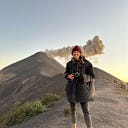
8 | Once you land back on the dirt, you should clearly be able to see the top of the hike and the caldera rim of Sollipulli. This last section is quite steep — though very short. Keep pushing until you get to the rim where you will be rewarded with amazing views of the ice sheet inside the caldera as well as the colorful mountains that line the outside.
❔GOOD TO KNOW: the wind can be quite strong up at the caldera rim. Plus, due to all of the ice and snow around, the wind can be quite cold (it seems to cut through you a bit). Come prepared with warm clothing including jackets, gloves and a hat so you can take in the beauty of the caldera in comfort.
Even though we headed out on a number of grand adventures while living in Pucón, we think Sollipulli might have just been one of our favorites. The massive ice sheet, epic caldera rim, stunning mountain views and beautiful araucaria forest really made this one special hike. Seriously, if you are looking for an epic hiking trip, we cannot recommend this trail enough.
If you have any questions about Sollipulli or the Pucón area in general, please leave a comment below or reach out to us at www.backroadpackers.com.
>> Want even more epic views of Sollipulli? Then check out the video that we put together of the hike. Find it here.